

Subtropical Storm Josephine developed late Wednesday afternoon offshore parallel to the U.S. Northeast, becoming the 10th named storm of the 2026 Atlantic hurricane season and the season’s first subtropical system. The storm is expected to strengthen as it tracks away from the United States, passing south of Nova Scotia before accelerating into the North Atlantic. So far this season, one hurricane has formed, and it also became a major hurricane: Isaias.
By Oct. 22, there are typically hurricanes, 2 major hurricanes, and 12 tropical storms that would have formed.

What makes a storm subtropical?
Subtropical cyclones share features of both tropical and extratropical weather systems. While fully tropical cyclones get most of their energy from warm ocean waters and heat released within thunderstorms, subtropical systems draw on both ocean warmth and atmospheric temperature contrasts. Their wind and thunderstorm patterns also differ from those of traditional tropical storms. In a tropical cyclone, the strongest winds are generally concentrated near the center. Subtropical storms, however, tend to have their strongest winds farther from the circulation center, with thunderstorm activity often displaced well away from it. These hybrid systems often maintain a warm core in the lower atmosphere while showing characteristics of non-tropical low-pressure systems.

Josephine could produce hurricane-force winds during transition
According to the National Hurricane Center’s 11 a.m. advisory, Josephine was moving northeast at 12 mph, with maximum sustained winds of 65 mph. Forecasters expect the storm to strengthen further as it gradually transforms into an extratropical cyclone. During this transition, Josephine’s circulation is likely to expand, spreading strong winds across a considerably larger area. As Josephine passes south of Nova Scotia on Friday, its expanding wind field could bring stronger sustained winds to the region. Although Josephine may eventually generate hurricane-force sustained winds, that would not automatically make it a hurricane. To receive that classification, the cyclone would need to develop a fully tropical structure. Such a transition is not anticipated. Instead, Josephine is expected to become an extratropical low-pressure system capable of producing hurricane-force winds.
Not a Florida storm or impacts to Florida
Local National Weather Service offices have issued coastal flood advisories and wind-related alerts across the Mid-Atlantic and Northeast over the past several days. The National Hurricane Center has issued alerts across offshore waters, far from Florida.
Josephine is expected to remain a named storm only briefly before transitioning into an extratropical cyclone. Through Thursday and early Friday, the storm will travel across relatively warm waters associated with portions of the Gulf Stream. This ocean heat could support additional strengthening before Josephine loses its subtropical characteristics. Forecasters indicate the system could transition into an extratropical system with hurricane-force winds cs early as late Thursday or early Friday morning. A larger low-pressure system will absorb the system during the latter part of the weekend.

Florida's forecast: King Tides!
Florida can expect a mix of sunshine and clouds heading into the weekend, with temperatures remaining warm across much of the state. Afternoon highs will generally be in the 80s across central and southern Florida, while northern areas may be slightly cooler. A few passing showers are possible, particularly along the Atlantic coast and across South Florida, although widespread rainfall is not expected to dominate the forecast.

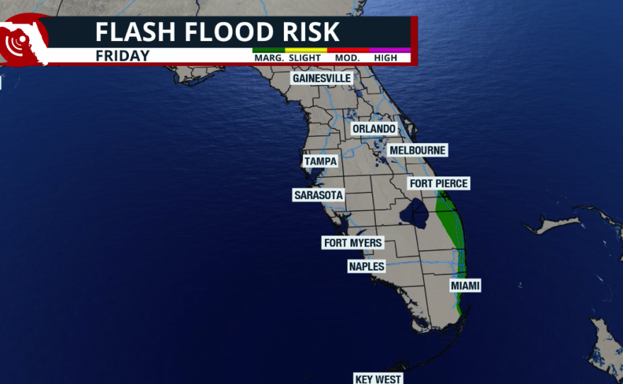
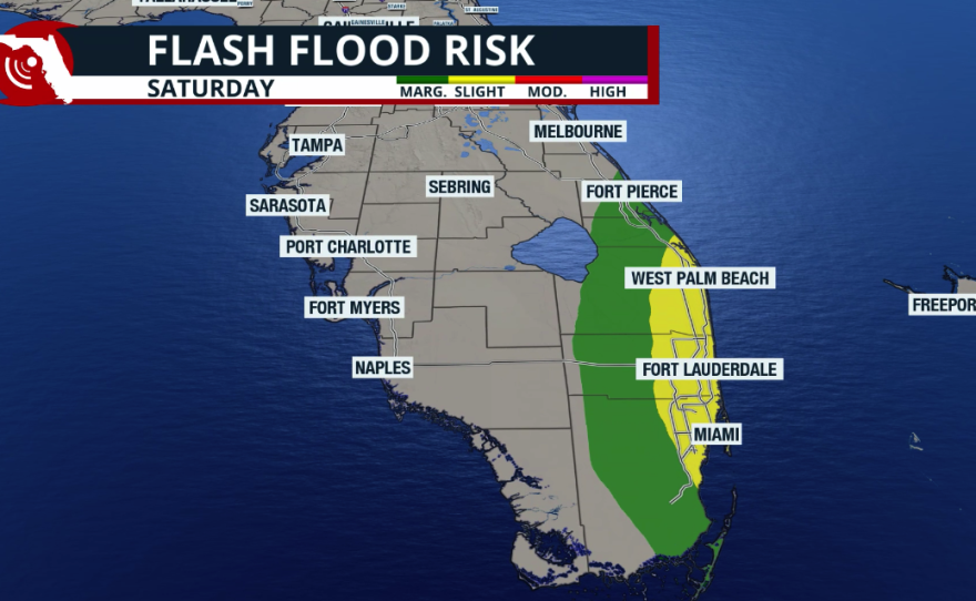
The biggest weather concerns will develop over the weekend, especially across South Florida, where increasing tropical moisture and a developing upper-level disturbance near Cuba are expected to bring rounds of heavy rain Saturday and Sunday. Rainfall totals of 3 to 6 inches are possible along the southeastern coast, with locally higher amounts potentially causing flash flooding. Gusty northeast winds of 30 to 40 mph, rough surf, dangerous rip currents, and coastal flooding around high tide will add to the hazards. Meanwhile, much of central and northern Florida should remain comparatively drier, although breezy conditions and hazardous beach weather will continue along the Atlantic coast.
We are moving through a round of King Tides, or Perigean Spring Tides (the official and scientific name). These tides happen when the Sun, Moon, and Earth align, creating a stronger gravitational pull on our planet. As a result, we expect higher-than-normal high tides and lower-than-normal low tides throughout the weekend. Along Southeast Florida’s low-lying coastline, these tides can lead to minor coastal flooding even without rainfall or strong onshore winds.

Coastal flood advisories are being issued as needed. Winds will shift and come onshore more prominently throughout the weekend, becoming more direct and, at times, stronger. This shift could worsen coastal flooding even without rain, especially during high tide. Check your local tide times here.
King tides are expected today, October 22 through Friday, October 30, with the highest tides predicted on Monday, October 26 and Tuesday, October 27.
— City of Miami Beach (@MiamiBeachNews) October 22, 2026
These higher-than-normal tides may cause flooding in low-lying areas throughout the city.
NOAA peak tide time predictions:… pic.twitter.com/ojeeTvosPb
If you encounter flooding, never drive or walk through the water. Saltwater can corrode vehicles, and the floodwaters can also contain pollutants, including bacteria and sewage, which may pose health risks, especially for anyone with open wounds.
