By multiple measures, the month of May was notable for weather extremes in north Florida. The average high temperature for May in Jacksonville was 88.8 degrees. That is highest May average high temperature for Jacksonville in recent history, going back to 1998.
The 2nd hottest May in Jacksonville was 2006, that year the average high was 88.5 degrees. In Gainesville, heat was also higher than normal for May. There were 15 days in May where the Gainesville’s high temperature was higher than 93 degrees. That is the 3rd most for May, behind 2011 with 17 days above 93 and way back in 1899, when 19 days in May were hotter than 93 degrees.
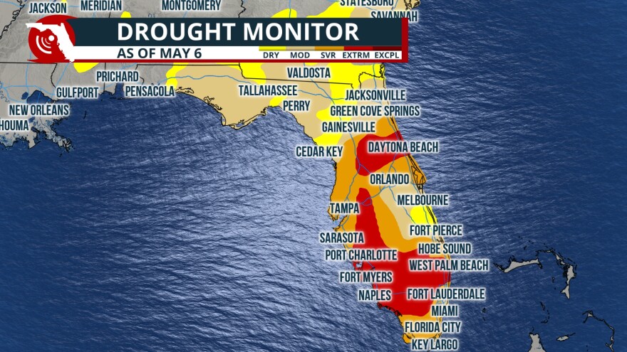
May started with most of the panhandle in abnormally dry to moderate drought conditions. Panama City, Pensacola and the Tallahassee areas were all in moderate drought. Abnormally dry to moderate drought conditions also extended westward into the First Coast and Jacksonville areas. Stalling cold fronts through the past several weeks led to gains in this area into early June.

Farther south into the peninsula, May provided some beneficial rainfall. In central Florida, rainfall deficits were more significant early in the month and areas near Ocala and eastward to the Daytona Beach and the Space Coast were in “Extreme” drought. Another large area of “Extreme” drought extended across the entire peninsula from the Fort Lauderdale area westward to the Naples area. As of May 1st, the Climate Prediction Center had only 1.26% of Florida not in some level of drought.
By June 10th, the percentage of Florida that was no longer in drought had risen to over 35%. At the same time, the area of the state in the “Extreme” drought category had dropped from around 17% to under 4%. Gains in rainfall in this area are due to an uptick in daily thunderstorms, typical of early summer and from a slow moving upper level low that tracked northward in the western Gulf in late May.

