
Florida's forecast will remain hot and humid, with daily afternoon thunderstorms primarily developing across the peninsula's interior. Winds will begin to shift by the end of the week, leading to some changes in storm coverage and temperatures.
There are some changes coming to Florida this week into the weekend. Yep! You guessed it! MORE HEAT!
— Florida Public Radio Emergency Network (FPREN) (@FloridaStorms) June 24, 2026
Several records could be tied or broken.
First, a front will enhance the storm chance for the western Panhandle on Wednesday. pic.twitter.com/cBEN1zw5tT
Wednesday and Thursday
The Florida Panhandle will remain under the influence of a weak frontal boundary through Thursday. This front will gradually dissipate during the day on Thursday, but it will enhance the potential for showers and thunderstorms across the region, particularly over the western Panhandle. Some storms on Wednesday and Thursday could become strong and produce excessive rainfall in a short period. As a result, localized flash flooding may develop, especially along the Interstate 10 corridor from Tallahassee westward to Pensacola.

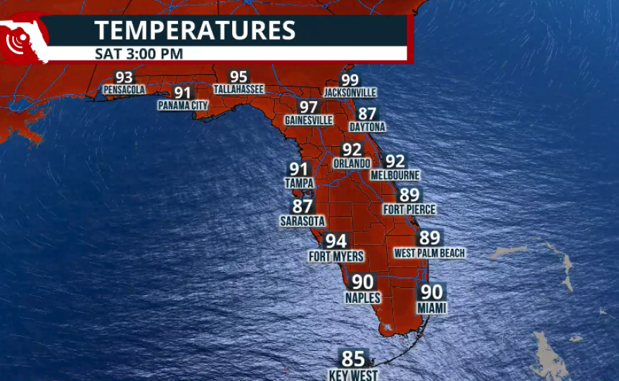
Weekend Pattern: High Pressure Takes Control
Once the front dissipates, high pressure will build across the region just in time for the weekend. This will not only occur at the surface but also in the middle and upper levels of the atmosphere. The combination of these high-pressure systems will promote sinking air, limit the development of widespread storms, and allow temperatures to climb.
At the surface, a high-pressure system centered over the western Atlantic will keep winds blowing mainly from the west-southwest across the Florida Peninsula. This setup typically favors the hottest temperatures across Central Florida and the eastern portions of the state. As air travels over Florida's hot landmass, it continues to warm, resulting in the highest temperatures occurring across the interior and eastern areas. If winds were coming from the east, the east coast would remain somewhat cooler while the hottest temperatures would shift toward the interior and western sections of the peninsula.

Rainfall and Thunderstorm Outlook
For the remainder of the workweek, shower and thunderstorm development across the peninsula will be driven primarily by the sea breeze. Outside of the frontal influence in the Panhandle, the greatest concentration of storms should remain south of the Interstate 4 corridor and across South Florida. Wednesday and Thursday afternoon, a few isolated severe thunderstorms are possible across the peninsula, with the greatest impacts expected over interior and eastern sections as winds remain out of the south-southwest. A similar pattern will persist through the rest of the workweek, with afternoon showers and thunderstorms developing mainly over interior locations, especially across the southern half of the peninsula.
As upper-level high pressure strengthens over the weekend, sinking air will suppress widespread thunderstorm development. Isolated afternoon storms will still be possible, but coverage should be noticeably lower than what is expected on Wednesday and Thursday. With fewer storms available to provide cooling rainfall, temperatures are expected to remain very hot throughout the weekend.


Heat and Potential Records
Some locations between Tampa and Orlando, including Sarasota, may approach daily record highs on Saturday and Sunday. Afternoon temperatures in the Orlando–Tampa–Sarasota corridor are expected to reach 95°F to 96°F, potentially challenging records at several official climate stations. Humidity levels will remain extremely high across the state. While actual air temperatures will generally range from the lower to middle 90s throughout the peninsula, heat index values could climb to around 105°F during the hottest part of the afternoon. If you have outdoor plans this weekend, be sure to stay hydrated throughout the day and limit prolonged exposure to the heat. If you must spend extended time outdoors, take frequent breaks in the shade or air conditioning and drink plenty of water.

