
Despite spending much of 2025 under the influence of La Niña, Florida’s weather was relatively subdued compared to recent years when destructive hurricanes and billion-dollar disasters were commonplace.
While the year did feature several extraordinary events - including a once-in-a-century snowstorm along the Gulf Coast and flash flooding in October - none reached the scale of devastation Floridians have grown accustomed to.
There were no hurricane landfalls in Florida or anywhere else in the U.S. during 2025, and severe weather reports from around the state were roughly half of what is typically observed during an average year.
Most communities across the state did experience drought conditions, though an unusual late-season wet pattern helped minimize the risk of wildfires across the peninsula.

According to preliminary data from the Southeast Regional Climate Center, many Florida communities rounded out 2025 as one of their top 10 warmest years on record while also seeing significant precipitation deficits.
Among the most notable events were the following weather stories that defined Florida’s climate.
1. Historic Gulf Coast snowstorm
Undoubtedly, the most historic event of 2025 unfolded in January, when a winter storm impacted the Gulf Coast.
Snow was reported from Texas to the Florida Panhandle, shattering long-standing records.
Some communities in Santa Rosa County reported up to 10 inches of snow, while Pensacola officially measured 8.9 inches. Jacksonville even saw a few flakes, marking its most snowfall in 35 years.


Thousands along the Interstate 10 corridor lost power, and Gov. Ron DeSantis declared a state of emergency.
Travel west of Tallahassee was essentially shut down as nearly 70 miles of I-10 were closed, and operations at airports in Tallahassee and Pensacola were halted until the ice and the snow melted.
2. Central Florida tornado
Severe weather made a notable appearance in March, when thunderstorms along a cold front produced multiple tornadoes across Florida, including the Orlando metro area.
The most significant twister touched down March 10 in Seminole County and was rated EF-2 on the Enhanced Fujita Scale.
A damage survey indicated winds reached up to 120 mph at the tornado’s strongest point, along Interstate 4.

No significant injuries or fatalities were reported, though property damage was estimated to be at least $4 million.
Additional severe weather from the storm system was reported in Okeechobee, St. Lucie and Orange counties.
The tornado was one of just more than two dozen reported statewide, roughly half the number observed during a typical year.

3. Quiet hurricane season for Florida
Florida and much of the U.S. experienced its least impactful hurricane season in more than a decade.
From June through November, 13 named storms formed, with four becoming major hurricanes.
Swells from two Category 5 hurricanes - Erin and Humberto - caused coastal flooding and significant erosion along Florida’s east coast despite the cyclones staying hundreds of miles off the coast.

Not seeing a landfalling tropical cyclone is not unusual; the state previously went from 2006 through 2015 without seeing a hurricane make a direct landfall.
The position of the Atlantic ridge allowed most cyclones in 2025 to recurve harmlessly over the open ocean.
4. Summer dominated by heat waves
All three months of meteorological summer finished among the warmest of their respective months, resulting in the sixth-warmest summer on record statewide.
The final month of meteorological summer ranked as the ninth-warmest August in Florida’s history.
Several communities reported experiencing multiple record-breaking high temperatures.
Gainesville, Melbourne and West Palm Beach all recorded above-average temperatures in August, while rainfall totals varied widely across the state.
What made the summer somewhat more bearable than it otherwise would have been was that much of the heat was dry, with reduced humidity levels.

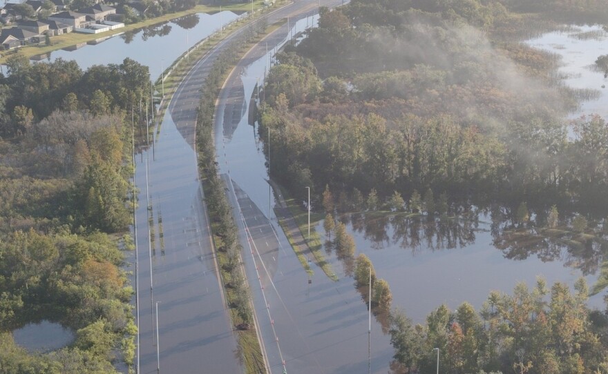
5. October flash flooding
The year’s most widespread rainfall event arrived in late October, when slow-moving tropical moisture triggered flash flooding across parts of Central and South Florida.
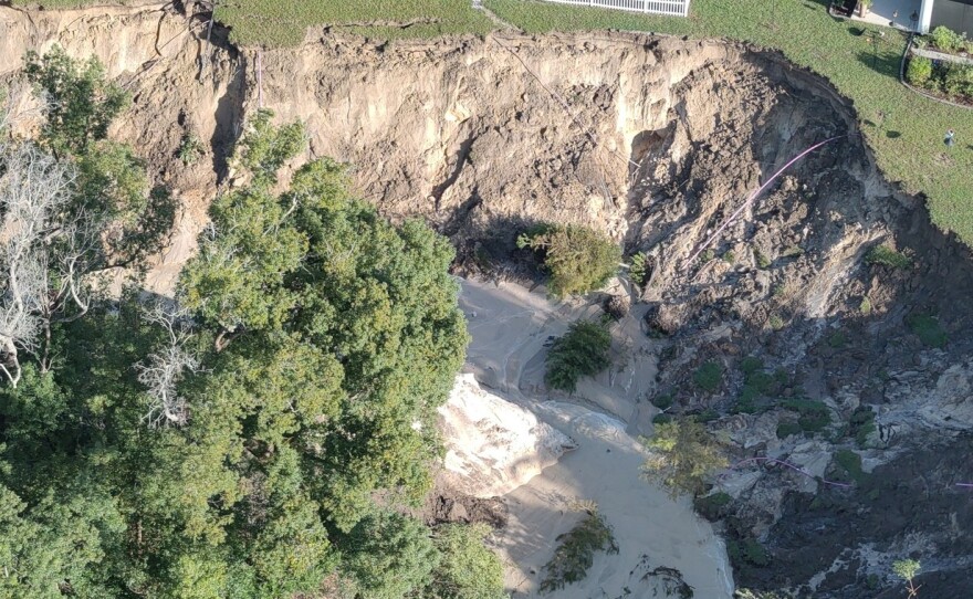
Lake County experienced widespread impacts, with several roadways that were washed away after more than a foot of rain fell.
The National Weather Service issued a Flash Flood Emergency, an unusual designation outside of a tropical system.

Farther south, communities in Palm Beach County were inundated late in October after more than 7 inches of rain fell.
Experts at Florida Atlantic University estimated roughly 1 billion gallons of rain fell in just a few hours, flooding streets and vehicles in the Boca Raton area.
Despite the heavy rainfall, some South Florida communities remained on track to finish 2025 with deficits of precipitation.