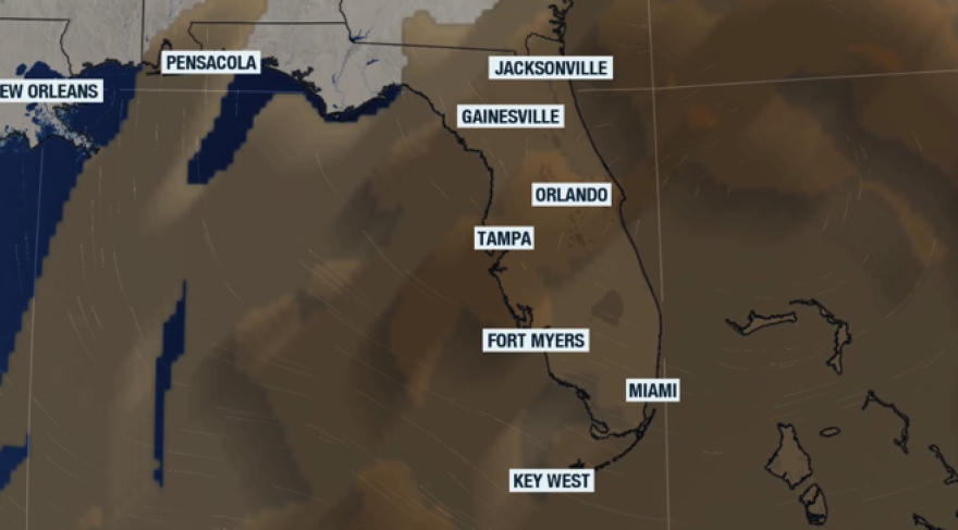
As we move closer to the weekend, the moisture that affected much of Florida around the middle of the week begins to move away. This is the same area where we have been watching for tropical development. Its chances continue to wind down, and give way for much dry air to arrive in the Sunshine State.

We’re not only expecting dry air, but also Saharan dust that will blanket Florida throughout the weekend. This, combined with a high-pressure system centered directly over the peninsula on Saturday, will disrupt the typical summer afternoon storm pattern.
Much of Florida takes a break from the storms, and Saharan dust takes over, making the temperatures soar.
— Florida Public Radio Emergency Network (FPREN) (@FloridaStorms) July 25, 2025
At least the dust gives us gorgeous sunrises and sunsets.
Hydrate! pic.twitter.com/jc9NrYiizN
The skies will remain mostly yellowish on Saturday as Saharan dust covers most of the peninsula. Dust and a high-pressure system are a combination that leads to extra hot temperatures. Saturday afternoon will feature temperatures in the low to mid-90s from South Florida through the panhandle. However, the humidity will make these temperatures feel like they are in the triple digits. The evenings will not be cooling either; low temperatures on Sunday morning will stay around the mid-70s across the southern half of the Peninsula and the western half of the panhandle, while north Florida will struggle to drop below 78°F.
Hotter temperatures expected Friday, and especially over the weekend and early next week. Stay in tune for any heat advisories over the next few days as we move through the weekend. pic.twitter.com/Ri9osKiSOK
— NWS Jacksonville (@NWSJacksonville) July 24, 2025
Overall temperatures should remain slightly warmer along the western half of Florida, as the winds will be mainly coming in from the east-southeast, especially on Saturday, having plenty of time to warm as they travel over land. By Sunday, the winds will shift, coming in from the northwest, which would also keep the warmest temperatures focused along the West Coast of Florida, mainly from Tampa through Naples.
Although much of the peninsula should remain rain-free on Sunday, there’s a slight chance for some afternoon thunderstorms to move over the west Central coast of Florida on Sunday afternoon.
Check out the spin of the Saharan dust & depth over Florida.
— Florida Public Radio Emergency Network (FPREN) (@FloridaStorms) July 25, 2025
Get those cameras ready. Aside from causing hot temps, the dust particles turn the skies all kinds of colors during sunrise & sunset. Enjoy, but remember to drink water too.
Read your forecast: https://t.co/F358L4nBY4 pic.twitter.com/5UyJuo3kfR
Saharan dust takes over this weekend.
Although this Saharan dust will give us beautiful sunrises and sunsets this weekend, if you suffer from respiratory issues, make sure to limit your time outdoors. When engaging in outdoor activities, be sure to wear plenty of sunscreen and stay hydrated.
🌊 7/24/25: There's a moderate to high risk of rip currents statewide!
— FL Division of Emergency Management (@FLSERT) July 24, 2025
🏖️ Be cautious at unguarded beaches
⚠️ Pay attention to beach warning flags
🌊 Know how to spot a rip current & safely escape one
➡️https://t.co/e29GQ9Rg4C pic.twitter.com/HT6aE6KikQ

