
A monster storm that’s traveling across the Great Lakes and the Northeast is pushing a cold front that’s bringing heavy rains from the Great Lakes through the Eastern Seaboard. Several key factors are notable about this extensive low-pressure system.
First, this low-pressure system is more than 1,000 miles wide. It is also pulling large volumes of warm air from the south, which is allowing almost all precipitation that’s falling over the United States, associated with this storm, to remain as liquid. Lastly, this system is bringing powerful winds across a large portion of the Great Lakes and, on Friday, across the Northeast. This windstorm is likely to disrupt air travel at major airport hubs, which could ultimately affect travel to and from Florida.

Florida’s forecast
The cold front has already entered the Sunshine State, but the coolest air will not be experienced until Saturday morning for most. Much of the precipitation is well ahead of the cold front and has affected parts of the Panhandle, bringing rounds of showers and scattered thunderstorms on Thursday. By Friday, the precipitation will be mainly focused across the southern half of the peninsula, from the I-4 corridor southward. Don’t expect plenty of rain, though; this cold front continues to fizzle, and its moisture continues to dissipate as it moves southward. Therefore, there will only be a few scattered showers from parts of Kissimmee through South Florida during the afternoon hours.
Another cold front is pushing through Florida, but it is also another one that will not bring long-lasting changes.
— Florida Public Radio Emergency Network (FPREN) (@FloridaStorms) December 19, 2025
The coldest morning will be Saturday for everyone. pic.twitter.com/NqmDe9OYB6
Dry air will continue to sink in place across the Panhandle by Friday, and clear skies will persist during the late morning and afternoon across North Florida.
The cold this morning for North Florida and the Panhandle will be on Saturday morning. Expect temperatures in the 30s for one night across the Panhandle and parts of North Florida, with lows in the low 40s.


Across Central Florida, cold air will begin to sink in on Friday evening and continue into Saturday morning. Temperatures on Saturday morning are expected to range from 48 to 50 °F from Tampa to the Space Coast. There will be a significant temperature difference between Miami and Cape Coral, as the cold air will not reach South Florida by Saturday morning. In fact, the coldest air will be moderating fast, and temperatures are expected to be around the mid-60s for the southeast Metro area. This will likely be the coldest morning for Miami, Dade, Broward, and Palm Beach.

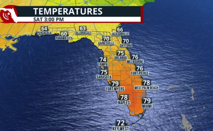
Sunshine will be the main character throughout much of the weekend. On Saturday and Sunday, expect temperatures to remain in the low 80s across southeastern and southwestern Florida, while Central Florida will stay around the mid-70s. The Panhandle and parts of Northeast Florida will be the coldest areas. Cities such as Jacksonville will have highs around the mid-60s on Saturday and Sunday, rising to the low 70s along the I-10 corridor.

Christmas week outlook
Warm weather is here to stay. The long-term outlook shows significant warmth affecting much of the United States. Christmas is expected to be warmer than usual, with temperatures 5°-10° above average for this time of year. But in fact, Florida could be one of the few areas with temperatures closest to normal, although still above average, for this time of year. In long-term models, parts of the central United States could be 40° above average for this time of year. It’s going to be a toasty Christmas for millions of people.
