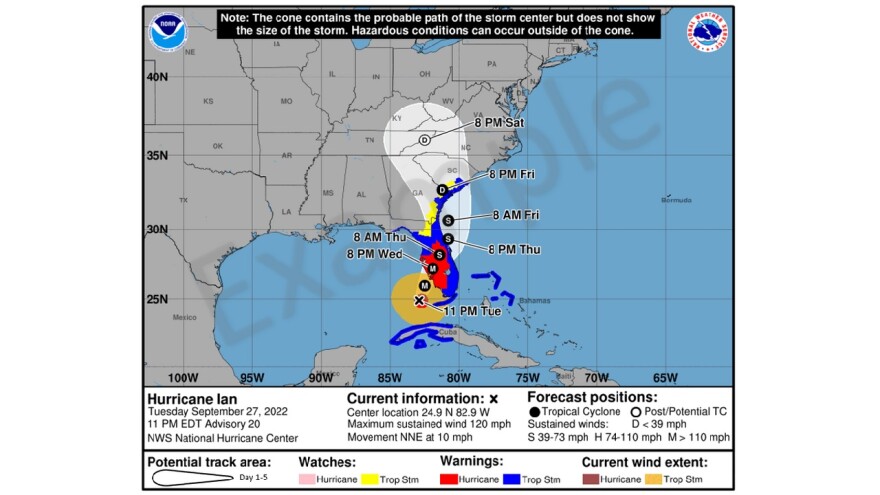
The National Hurricane Center (NHC) has released a new experimental forecast cone for storms. And it’s the most significant change to the forecast track since 2017. The new cone includes inland watches and warnings to highlight the inland risk of damaging wind gusts from landfalling tropical systems. The image below is an example of how the new product will look.

Today, the NHC launched the new experimental product with Ernesto. Ernesto is not expected to impact inland areas of the United States directly, so the forecast map looks virtually unchanged from previous versions.
But we’ve made a tutorial video to help make the new changes easier to see. Please remember, the images used in this video are only an EXAMPLE, and not a current forecast track of a current tropical system.
The NHC premiered the new cone at the American Meteorological conference earlier this summer to meteorologists around the country.
From @AMSBroadcastcon: New experimental @NHC cone this year on the right. Current on the left. Will emphasize watches & warnings rather than storm track (cone) to emphasize storm impacts typically extend beyond the cone. #ncwx #scwx #cltwx #amsbc51 @AMSBroadcaster pic.twitter.com/iHehMjdHGn
— Al Conklin WBTV (@AlConklin) June 13, 2024
In this side by side comparison on 'X', you can see the current forecast cone on the left. The new experimental cone this year is on the right. Among several features, the new cone will emphasize inland watches & warnings rather than just on the storm’s track. The NHC is hoping with this information on one page, it will make it easier to understand for the public. They want to emphasis that conditions from a landfalling hurricane or tropical systems typically extend far beyond the cone. And with the inland watches and warnings present on the forecast cone, this will help more people prepare earlier, and better in the future.
It’s important to remember that the experimental version will show watches and warnings for inland areas in the continental United States, in addition to those in effect along the coast. The NHC is looking at adding this feature to other parts of the world in the coming years.
You can always get any information about the current state of tropical systems by visiting the NHC’s website.


